The 18 Scariest and Most Dangerous Roads in the World

Bolivia's Road of Death
Many People Die on These Deadly Highways
This article compiles a list of some of the most dangerous roads in the world. Videos are provided for each road, many of which show people traveling over some of the roughest terrain on the planet.
So, if you don’t get frightened too easily and can handle the perilousness of these roads, fasten your seatbelt, and let's take a virtual ride. And if you’ve actually traveled on any of these awesome avenues, please let the author know.
Now, let the countdown begin!

Stelvio Pass
18. Stelvio Pass (Eastern Alps)
Location: Border between Italy and Switzerland
Length: Unknown
Maximum Elevation: 9,045 feet (2,757 meters)
Dangers: hairpin turns, steep grade
Considered by Top Gear magazine to be the greatest driving road in the world—though some experts think the Transfaugarasan Highway in Romania is better—it must be positively grand to drive Stelvio Pass in a Ferrari or other high-performance sports car. Often used for cyclists or runners in competitions such as the Grand Tour or Stelvio Marathon, Stelvio Pass has 75 hairpin turns and probably shouldn’t be traveled at all at night or during the winter, when it’s often closed because of weather conditions. Good luck!

Hell's Gate on Skippers Canyon Road
YSander, CC BY-SA 3.0, via Wikimedia Commons
17. Skippers Canyon Road (New Zealand)
Location: New Zealand
Length: 16.5 miles (26.5 kilometers)
Maximum Elevation: Unknown
Dangers: Unpaved, no guardrails, narrow road, steep cliffs

When Skippers Canyon became a popular gold-mining area, the need for safer access to it increased. (Yes, while the road is still dangerous today (claiming hundreds of lives every year), it is far safer than the miners' original track.) It took seven years to carve this gorgeous and frightening road out of the cliff face. It was completed in 1890, and many sections of the road remain the same today as they were then.
Today, the road is frequented mostly by tour buses and adventure companies (pity their drivers!).

Traffic on the Kabul to Kandahar section of the Ring Road
16. Ring Road, Kabul to Kandahar
Location: Afghanistan
Length: 300 miles
Dangers: Huge potholes and craters, banditry, lack of law enforcement
The Ring Road from Kabul to Kandahar is perhaps the most drivable section of a circular highway system that stretches throughout the interior of Afghanistan for 1,400 miles. Although this section of the ring road is passable, it has many deep potholes, the damage from improvised exploding devices and drone strikes when the US military controlled the country for 20 years.
There’s also much traffic on this stretch of the Ring Road; 18-wheel trucks, buses and cars regularly trundle over the road, causing damage to it. Unfortunately, construction crews can only work on the road if there’s money for repairs—which can be difficult to obtain in a poor country—and only if work crews are escorted by heavily armed guards.
Since the US military left Afghanistan in August 2021, it's unknown how safe this road is. At any rate, one should only travel on it during daylight hours, when the weather is clement—and carrying a gun or two for protection in one’s vehicle wouldn’t be a bad idea, either. Good luck!

Typical logging truck
15. Butcher of the Extreme (France)
The author doesn’t know exactly where this road is located; nevertheless, it must be one of the most dangerous roads in existence. Of course, there are many other logging roads throughout the world, many of which are not paved, while others are little more than animal trails. At any rate, if traveling on this road is any indication of what this work entails, then the men and women driving logging trucks deserve pay for hazardous work—that’s for certain!

Cotahuasi Canyon
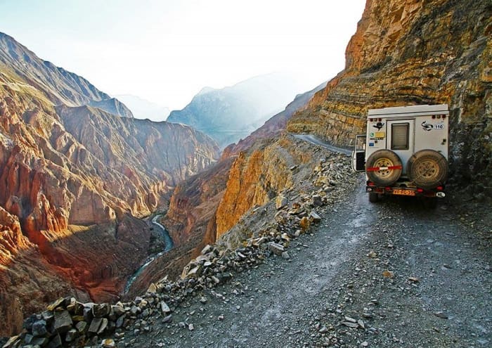
Cotahuasi Canyon Road
14. Cotahuasi Canyon Road
Location: Southern Peru
Length: Unknown
Maximum Depth of the Canyon: 3,525 meters or 11,595 feet
The Cotahuasi Canyon Road begins on the Pan American Highway near the city of Arequipa. A bus drive on the road takes 10 to 12 hours. The road is unpaved beyond Chuquibamba, where it’s quite dangerous in places, so only four-wheel drive vehicles should be used on this bouncy and scary stretch of the road. At present, the road has not been overrun with tourists and it’s easy to find places to camp along this deadly highway.
Please note that Cotahuasi Canyon is the third deepest canyon in the world and, for reference, more than twice as deep as America’s Grand Canyon. The world’s deepest canyon—above sea level, please keep in mind—is the Yarlung Tsangpo Grand Canyon in Tibet; its depth is 6,009 meters or 19,714 feet.

Are you brave enough to drive the Taroko Gorge Road?
Paul Arps, CC BY 2.0, via Flickr
13. Taroko Gorge Road (Taiwan)
Location: Taiwan
Length: 11.8 miles (19 kilometers)
Maximum Elevation: Unknown
Dangers: Narrow, blind corners, rockfalls, landslides, flooding, earthquakes
Similar to the Guoliang Tunnel Road (number 4 on our list), Taroko Gorge Road is carved out of and through the mountains. Due to the spectacular beauty of its surroundings, the road is well frequented in spite of its fearsome reputation. This means a slew of tour buses, cars, scooters, bicyclists, and pedestrians are all vying for space on the same narrow road—a frightening prospect, considering the number of blind turns and extremely narrow bends in the road.
The road is also very hard to keep in good condition, as heavy rainfall and typhoons often cause landslides and rockslides that leave sections of the road impassable.
While many who have visited say that it is well worth the danger, this is not a road for the faint of heart!
Taroko Gorge in Taiwan
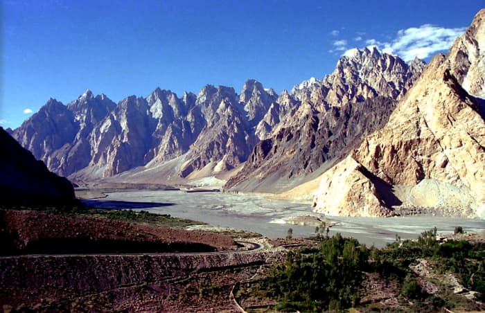
Cathedral Ridge in Pakistan

Typical truck on the highway
12. Karakoram Highway (Pakistan to China)
Location: Pakistan and China
Length: 810 miles (1,300 kilometers)
Maximum Elevation: 15,466 feet (4,714 meters)
Danger: Landslides, falling rocks, floods, avalanches, cliffs, and more...
Built as high as 15,000 feet above sea level and under very rough conditions, Karakoram Highway is sometimes considered the Eighth Wonder of the World. Construction on the road began in 1966 and was completed in 1979, although it wasn’t open to the public until 1986.
This dangerous road covers more than 1,300 kilometers and, at least in some places, follows the old Silk Road. Cutting through the most mountainous region in the world, the Karakoram Highway is beset with hazards: rock falls, landslides, avalanches, flooding, snow drifts, reckless drivers, herds of animals, precipitous cliffs and terrible storms.
Interestingly, the road meanders through the Hunza Valley, the scene of James Hilton’s Lost Horizon, a novel about the mythical Shangri-La, a harmonious place where people live for centuries.

Gandaki River
11. Pokhara to Jomsom to Mujtinath Road (Nepal)
Length: 96 miles (155 kilometers)
Elevation: 1,340 to 3,800 meters
Dangers: Blind corners, rockfalls, landslides, flooding, earthquakes, steep grades, huge potholes and muddy conditions during the monsoon
This scenic, though dangerous, Himalayan road, follows the Gandaki River, which winds through the Kali Gandaki Gorge, one of the deepest in the world at about 18,000 feet, as calculated by the elevation of the Gandaki River (8,270 feet) which runs among three of the highest mountains in the world: Dhaulagiri, Manaslu, and Annapurna I. Each is over 26,000 feet or 8,000 meters in height. Exotic beyond compare, this mythic region has many breathtaking sights!
But unpaved where this road is undergoing construction, the driver should be skillful—if not professional—and the vehicle must have four-wheel drive. Particularly worrisome are the road’s numerous overhanging rock formations. Comprised of boulders the size of houses, without warning a cliff face could collapse upon unwary pedestrians, cyclists or vehicles, causing serious injury or death!
Fairy Meadows Road
10. Fairy Meadows Road, a.k.a. Nanga Parbat Pass (Pakistan)
Length: 10 miles (16 kilometers)
Elevation Gain: ~8,000 feet (~2,400 meters)
Starting from Karakoram Highway and leading to the village of Tato, this road may only be 10 miles long, but it is absolutely harrowing. It is narrow (approximately the width of a Jeep Wrangler), unpaved, and unmaintained, and instead of guardrails, there is a multi-thousand-meter drop to the valley below. The road also climbs nearly 8,000 feet in a short distance, meaning much of the drive is composed of frighteningly steep sections. While the Fairy Meadows that await those who make the drive (and complete the rest of the hike on foot) are unspeakably gorgeous, few are brave enough to make it there.

99-Bend Road, China
Opui42, CC BY-SA 4.0, via Wikimedia Commons
9. 99-Bend Road to Heaven (China)
Location: China
Length: 6.8 miles (11 kilometers)
Maximum Elevation: 3,855 feet (1,175 meters)
Danger: Sheer drops, hairpin turns
It comes as no surprise that the country that brought us the Zhangjiajie Grand Canyon Glass Bridge and the rickety wooden walkways of Hua Shan also has its share of dangerous roads. Located in Tianmen Mountain National Park in central China, the 99-Bend Road to Heaven features—you guessed it—99 death-defying hairpin turns constructed hundreds of feet in the air. If you went off the road in such places, you’d surely die in a fiery crash.
In bad weather—with the ever-looming possibility of an earthquake—the road is incredibly treacherous. How many hapless folks must have died while constructing this highway in the sky?
The World's Curviest Roads (Most Hairpin Turns)
| Road | # of Hairpin Turns/Switchbacks | Elevation Gain* |
|---|---|---|
North Yungas Road, Bolivia | 200+ | 11,483 feet (3,500 meters) |
Three Level Zigzag Road, Himalayas | 100+ | 9,050 feet (2,759 meters) |
99-Bend Road, China | 99 | 3,609 feet (1,100 meters) |
Tsugaru Iwaki Skyline, Japan | 69 | 2,323 feet (708 meters) |
Los Caracoles, Chile | 17 | 768 feet (234 meters) |
Lacets de Montvernier, France | 17 | 610 feet (186 meters) |

Pan American Highway in Chile

Pan American Highway in the Atacama Desert
8. Pan American Highway (Alaska to Chile)
Location: North, Central, and South America
Length: 30,000 mi (48,000 kilometers)
Maximum Elevation: 10,499 feet (3,200 meters)
Danger: Inclement weather, difficult terrain, cartels, wild animals
The Pan American Highway (PAH) is not entirely dangerous, that is, it’s probably no worse than your average American highway. But in some places, you risk your freedom and even your life by using the PAH as a means of travel. Certainly, a dangerous section of the PAH winds through Mexico and Central America, where drug cartel terrorists roam.
And in the Panamanian section of the road, you could encounter FARC rebels, who often take captives and hold them for ransom, sometimes for years, while others never escape their makeshift jungle prisons. Anyway, the PAH is 30,000 miles long and the only broken section of the road is the 60-mile Darién Gap, between Panama and Colombia, where the FARC are even worse. Let’s hope they never complete the highway through there!

Sichuan-Tibet Highway

Sichuan-Tibet Highway
7. Sichuan-Tibet Highway (China)
Location: China and Tibet
Length: 1,330 miles (2,140 kilometers)
Maximum Elevation: 15,420 feet (4,700 meters)
Dangers: Rockslides, mudslides, avalanches, hairpin turns, cliffs
This very long highway connects Chengdu in Sichuan with Lhasa in Tibet, through an area known as Kham. Continuously beset with rockslides and avalanches, the Sichuan-Tibet Highway is a treacherous, switchback-laden highway that winds among towering peaks, often causing vomit-spewing altitude sickness in travelers.
Along the way, numerous Buddhist monasteries, red-robed Buddhists and herds of yaks can be seen. The road was built between 1950 and 1954 and since then, many thousands of people have died while traveling on the Sichuan-Tibet Highway (a shocking 7,500 deaths for every 100,000 drivers).

James Dalton Highway

James Dalton Highway during winter
6. James Dalton Highway (Alaska)
Location: Alaska
Length: 414 miles (666 kilometers)
Maximum Elevation: 4,739 feet (1,444 meters)
Dangers: Extreme weather, poor visibility, difficult terrain, steep grades, isolation, wildlife
Also known as the North Slope Hall Road, the James Dalton Highway is a road used by truckers, especially those who travel to and from the Prudhoe Bay oil fields on the north slope of Alaska. In fact, the road supports the Trans-Alaska Pipeline System.
The Highway is 414 miles long, paved in places, but about three-fourths of it is not. There are no medical facilities along the road, and only three towns exist along the way. It’s advised that anyone traveling the road should bring survival gear and plenty of supplies. Interestingly, the TV reality show, Ice Road Truckers, has many episodes dramatizing the rigors of traveling on this deadly, primitive road.
The Deadliest Roads in the USA
| Road | Deaths per Mile* |
|---|---|
I-4 (Tampa, FL to Daytona Beach, FL) | 1.25 |
I-45 (Dallas, TX to Galveston, TX) | 1.02 |
US 192 (Four Corners, FL to Indialantic, FL) | 0.87 |
I-17 (Flagstaff, AZ to Phoenix, AZ) | 0.84 |
I-95 (Miami, FL to Weston, MA) | 0.73 |
I-10 (Santa Monica, CA to Jacksonville, FL) | 0.7 |
US 175 (Dallas, TX to Jacksonville, TX) | 0.69 |
I-37 (San Antonio, TX to Corpus Christi, TX) | 0.65 |
US 290 (Junction, TX to Houston, TX) | 0.63 |
I-78 (Union Township, PA to New York City) | 0.63 |

July on the Siberian Road to Yakutsk

Mud on the Siberian Road to Yakutsk
5. Kolyma Highway and Lena Highway ("The Road of Bones")
Location: Russia
Length: 1,914 miles (3,080 kilometers)
Maximum Elevation: Unknown
Dangers: Extreme weather, unpaved roads, ice, mud, low visibility
Traveling through Siberia is always a challenge. Nicknamed the “Road of Bones,” this Siberian road from Magadan to Never meanders its way through one of the coldest regions in the world. It is a combination of two highways—the R504 Kolyma Highway and the A360 Lena Highway, both of which are subject to the same dangers (though the R504 is better maintained).
The highways are joined by the Lena River Ice Road, which is exactly what it sounds like a "road" across the river that is open yearly from December through April, when the ice is frozen enough to drive on...or so one hopes. Sadly, dozens lose their lives each year when their vehicles fall through the ice.
The preferred time to travel on the road is winter, when the ground and water are frozen, making travel somewhat easier (though you still have heavy snow, ice, and extremely low visibility to contend with). But during July and August, when it tends to rain a lot, the road becomes a monstrous quagmire, leading to traffic jams miles long. Only the most rugged 4X4 vehicles can manage this muddy beast. To make matters even worse, people get so bored during these traffic jams that they’ve been known to rob each other to pass the time!
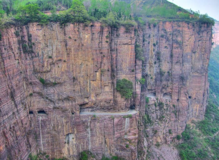
Guoliang Tunnel Road
FANG Chen from Beijing, China, CC BY 2.0, via Wikimedia Commons

Guoliang Tunnel Road
4. Guoliang Tunnel Road (China)
Location: China
Length: 0.75 miles (1.2 kilometers)
Maximum Elevation: 2,000 feet (600 meters)
Dangers: Sheer cliffs, no guardrails, extreme fog, rockfalls, mud
When the Chinese government decided it wasn’t worth the trouble and expense to make a road that would be used by only 300 villagers, 13 of those villagers decided to build a 0.8-mile tunnel through the solid rock of a vertical cliff. Located in the Taihang Mountains in the province of Henan, the villagers used explosives to blow their way through this vertiginous cliff. Lacking road-building experience, some villagers died in accidents.
The tunnel is 15 feet high and 12 feet wide, barely wide enough for two cars. Taking five years to build, the road was opened to traffic in 1977. Beware: This road is particularly dangerous when it rains!
Interestingly, at least two other cliff-tunnel roads have been constructed in this area of China.

Zoji La Pass

Zoji La Pass
3. Zoji La Pass (India)
Location: India
Length: 5.6 miles (9 kilometers)
Maximum Elevation: 11,575 feet (3,528 meters)
Dangers: Extreme weather, no guardrails, steep cliffs, narrow, unpaved
Just about any road that winds through the highest mountain range in the world would probably be at least somewhat dangerous to travel. The Zoji Pass certainly qualifies in this regard, since it’s a dirt road with no guardrails or traffic signs and where landslides are a continual problem. Moreover, the road zigzags among craggy peaks at over 11,000 feet at its highest elevation.
Connecting the towns of Srinagar and Leh in the western Himalayan mountain range (Indian Kashmir), Zoji Pass is generally closed during the winter, when 50-foot snowdrifts make it impassable. Mercifully for drivers on the road, Zoji Pass is only about 9 kilometers long. By the way, it was originally built in 1947 and first used for military purposes.
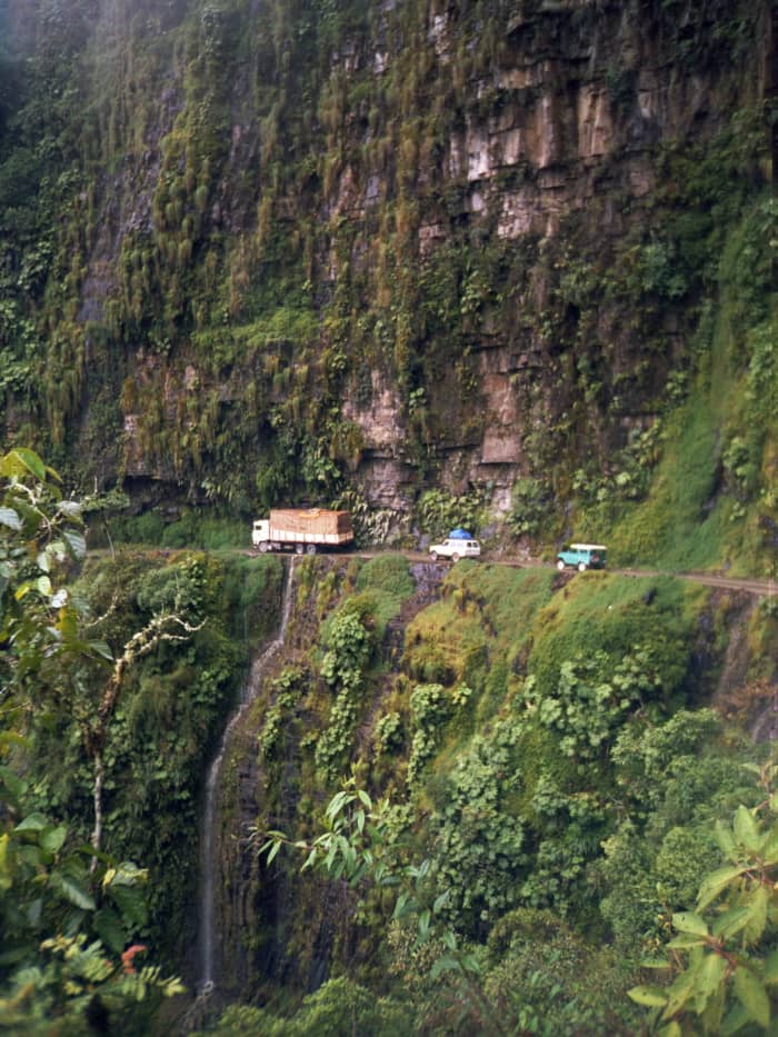
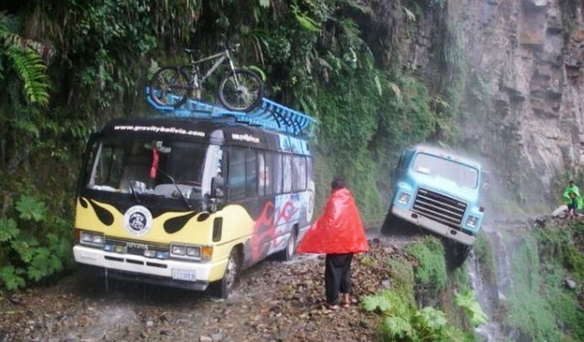
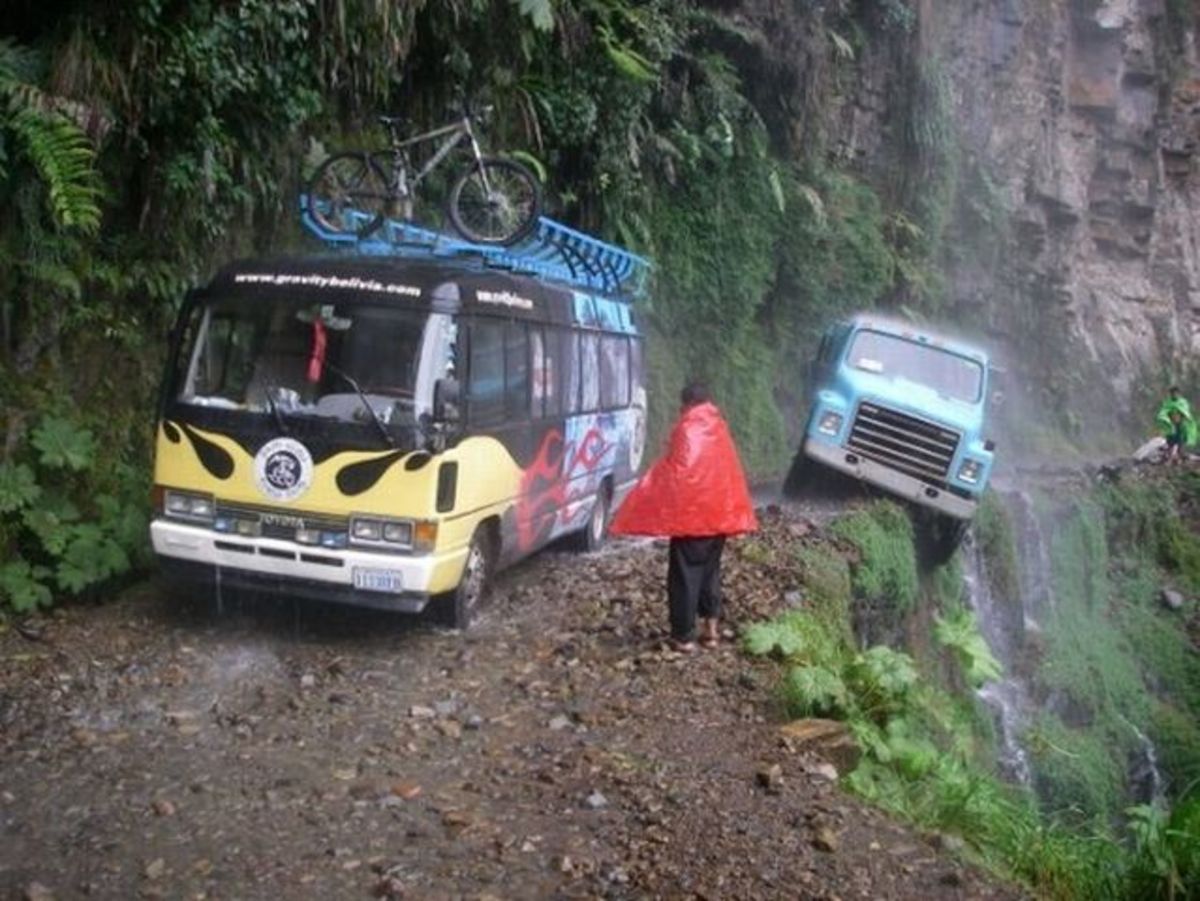
A procession of vehicles making their way along Bolivia's North Yungas Road.
Ilosuna assumed (based on copyright claims), CC BY-SA 3.0, via Wikimedia Commons

North Yungas Road
2. North Yungas Road ("The Road of Death")
Location: Bolivia
Length: 49.7 miles (80 kilometers)
Maximum Elevation: 15,256 feet (4,650 meters)
Dangers: Landslides, rockfalls, fog, cliffs, narrow road, no guardrails
If you don't want to travel on a road nicknamed “The Road of Death,” stay away from this one! Leading from La Paz to Coroico, the Road of Death is almost 50 miles of one-lane road, featuring vertical drops of as much as 3,000 feet into the Amazon rainforest below. Astonishingly, the road has over 200 hairpin turns.
Up until 1994, nearly 300 travelers died on the road every year. Numerous makeshift memorials can be seen in places where hapless folks have plunged over precipices and gone crashing down into the jungle ravines below. Fortunately, the worst part of the road has now been bypassed by a two-lane paved road, so vehicle traffic on the road has diminished. But cyclists still challenge the Road of Death, some dying in the process. Incidentally, the South Yungas Road to Cochabamba is considered almost as dangerous.
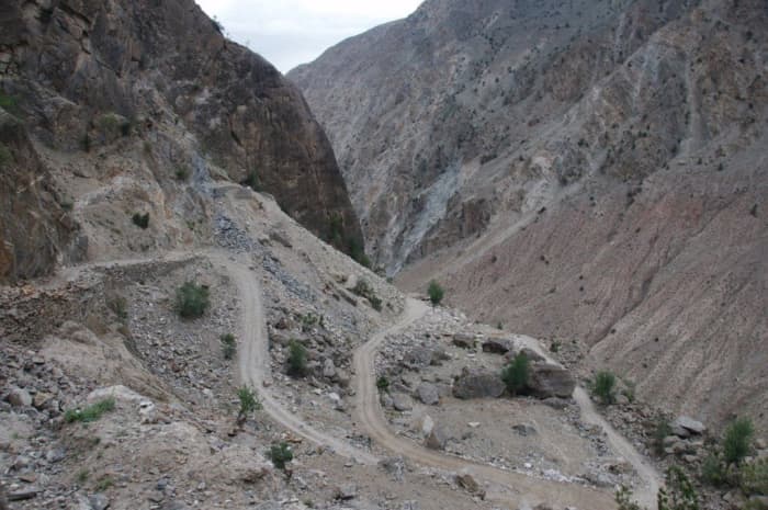
Killar to Pangi Road via Kishtwar

Killar to Pangi Road via Kishtwar
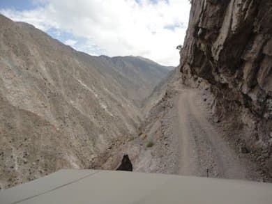
1. Killar to Pangi Road, via Kishtwar (India)
Location: India
Length: 70.8 miles (114 kilometers)
Maximum Elevation: 8,280 feet (2,524 meters)
Dangers: Steep cliffs, no guardrails, unpaved, mud, isolation
This hair-raising road is only for people who love to drive in the mountains and have nerves of steel. Open only during the summer months, this rocky, gravelly road is about 70 miles long. A six-mile stretch of it is particularly hazardous; rocky overhangs look as if they could fall upon the roadway at any moment. The road was built hundreds of years ago by local villagers and has not been repaired over the decades.
Only wide enough for one jeep at a time and having no guardrails, this dirt-and-gravel road is terrifyingly unstable in places. One false move by a driver could send a vehicle 2,000 feet down a vertical cliff. This road is so frightening that it’s hard to watch videos of people driving over it. If your bucket list has this one on it, make sure it’s your last challenge! Not sure if you're up to it? Check out this travelogue about driving the Killar to Pangi road for more photos of and details about this harrowing route.
The Steepest Roads in the World
| Road | Location | Gradient |
|---|---|---|
Canton Avenue | Pittsburgh, USA | 37% |
Waipio Road | Honokaa, Hawaii | 37% |
Baldwin Street | Dunedin, New Zealand | 35% |
Eldred Street | Los Angeles, USA | 33% |
Hard Knott Pass | Cumbria, UK | 33% |
Filbert Street | San Francisco, USA | 31.5% |
Recommended Videos
 10 Oldest Trees in the World32143 views
 A 200-Million-Year-Old ‘Giant’ Footprint Discovered In South Africa Is Known As The Mpuluzi Batholith2724 views
-
Advertisements
 This bizarre little succulent looks like a baby's butt261 views
 Two-Headed Alligator Reportedly Spotted In Florida307 views
 The Elusive Glass Octopus Finally Filmed In The Dark Depths Of The Pacific25939 views
 Meet Amazing Dull-Mantled Ant Bird, The World Nature's Hidden Gem124 views
 First Sunglasses Were Used 2,000 Years Ago By Iniut150 views
 Top 20 Beautiful Locations to Photograph in Australia1385 views